6. 2020 Easter Sunday Storm
The 2020 Easter Sunday storm is a widespread tornado outbreak that affected the Southeastern U.S on Apr 12-13.
6.1. Model Configuration and Datasets
The UFS Medium-Range Weather (MRW) Application (App) is used to prepare initial conditions, compile and run the UFS model, and post process the raw model outputs. Two model configuration compsets (GFSv15p2 and GFSv16beta) are tested using the C768 (~13km) spatial resolution with 64 vertical levels (default).
The case runs are initialized at 12z Apr 07, 2020 with 120 hours forecasting. The corresponding namelist options that need to be changed are listed below. The app uses ./xmlchange to change the runtime settings. The settings that need to be modified to set up the start date, start time, and run time are listed below.
./xmlchange RUN_STARTDATE=20200407,START_TOD=43200,STOP_OPTION=nhours,STOP_N=120
Initial condition (IC) files are created from GFS operational dataset in NEMSIO format. The GFS reanalysis dataset are used as ‘truth’ to compare with simulation results.
The GFS model EMC global workflow points to the most up-to-date GFS model development code. The GFS.v16.0.10 is tested in C768 (~13km) resolution and in 128 vertical levels. It uses two scripts, setup_expt_fcstonly.py and setup_workflow_fcstonly.py to set up the mode simulation date and case directories.
The case runs are initialized at 12z Apr 07, 2020 with 120 hours forecasting. The settings that need to be modified to set up the start date and directories are listed below.
./setup_expt_fcstonly.py --pslot 2020Easter --configdir /PATH/TO/YOUR/GLOBAL/WORKFLOW/parm/config --idate 2020040712 --edate 2020040712 --res 768 --comrot /PATH/TO/YOUR/EXP/DIR/comrot --expdir /PATH/TO/YOUR/EXP/OUTPUT/expdir
The account and simulation duration time can be set up in /expdir/2020Easter/config.base file.
./setup_workflow_fcstonly.py --expdir /PATH/TO/YOUR/OUTPUT/expdir/2020Easter
Next step is to go to /expdir/2020Easter to submit the run by
crontab 2020Easter.crontab
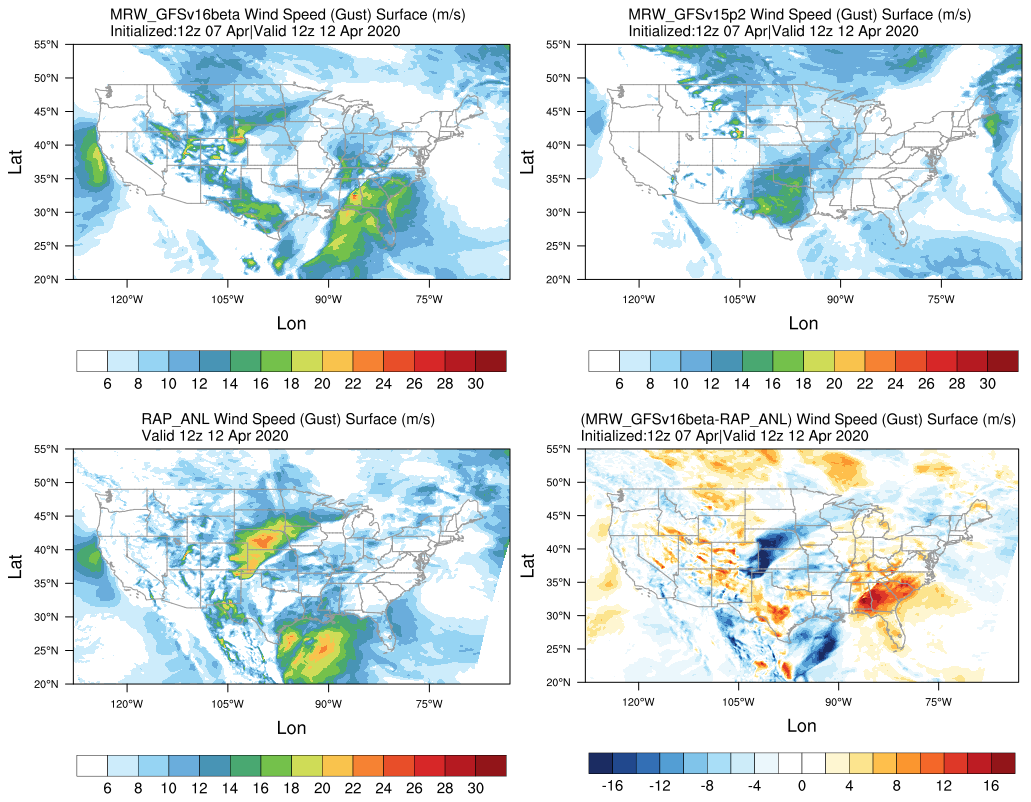
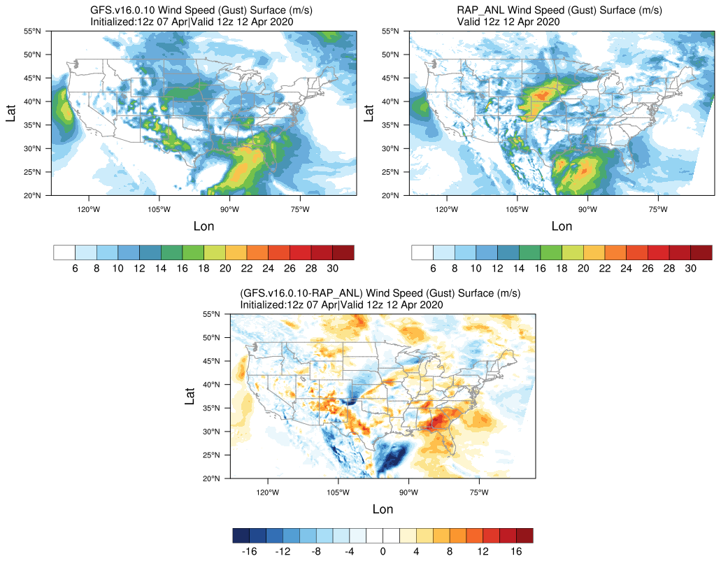
6.2. Case Results
6.2.1. Synoptic Dynamics
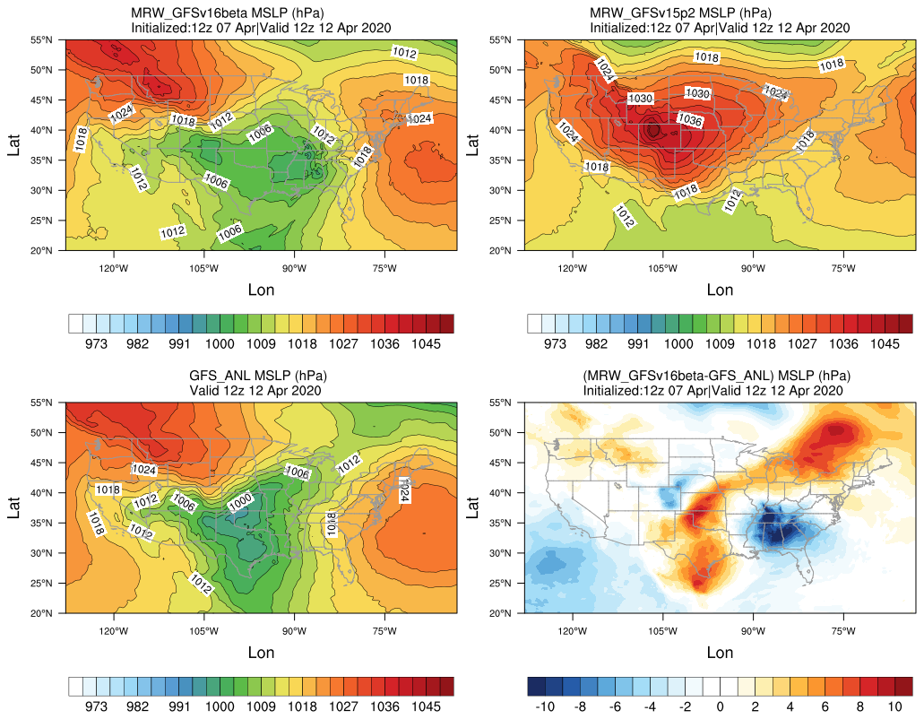
Mean sea level pressure (hPa)
MRW_GFSv16beta more correctly forecasts the surface low compared with MRW_GFSv15p2.
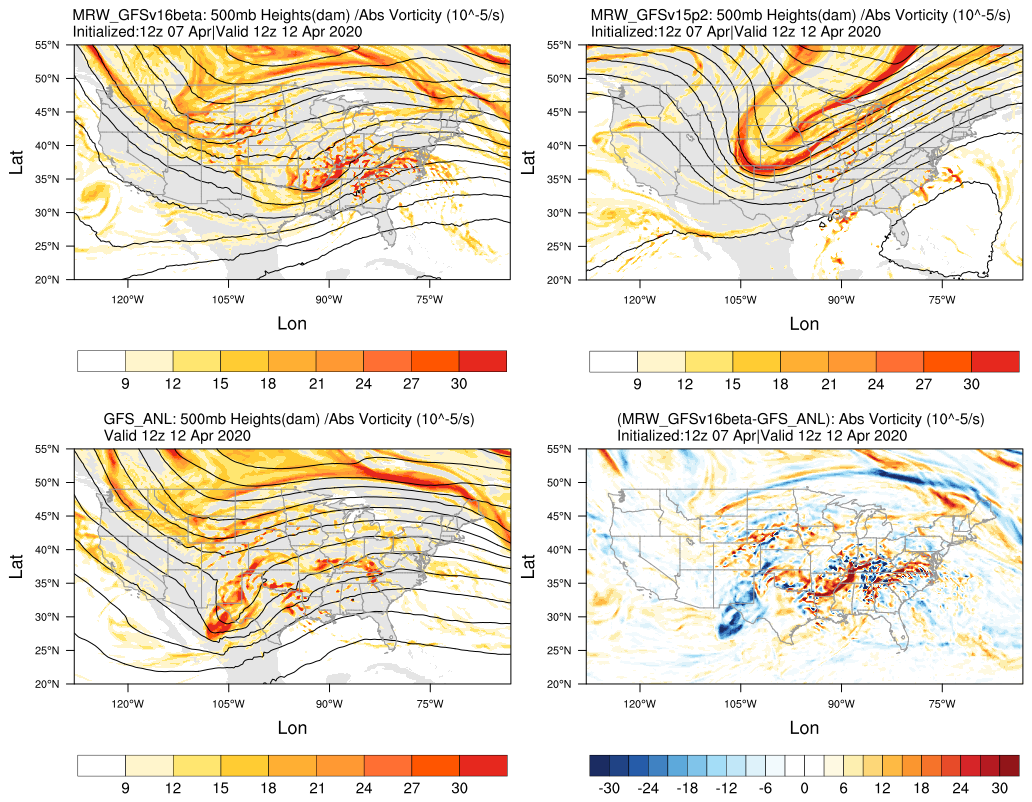
500 hPa geopotential heights (dam) and absolute vorticity (10 -5/s)
More positively tilted trough in MRW_GFSv15p2, suggesting a weakening weather system compared with GFS_ANL.
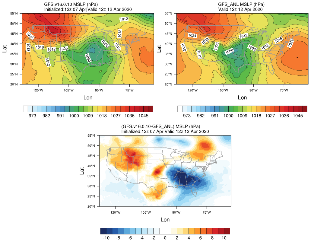
Mean sea level pressure (hPa)
GFS.v16.0.10 generates a surface low eastward of GFS_ANL.
The trough in GFS.v16.0.10 moves eastwards slightly faster compared with GFS_ANL.
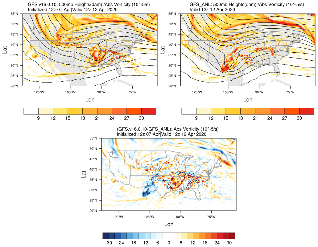
500 hPa geopotential heights (dam) and absolute vorticity (10 -5/s)
GFS.v16.0.10 generates a progressive synoptic pattern compared GFS_ANL.
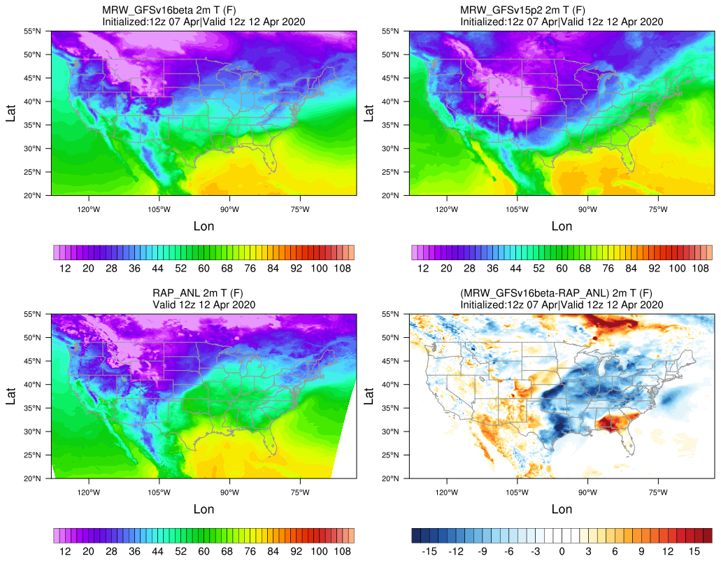
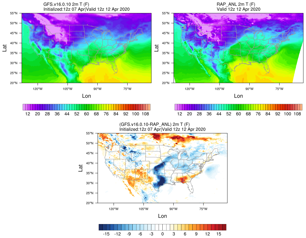
6.3. Summary and Discussion
The upper-level trough simulated in MRW_GFSv15p2 moves too fast northeastwards compared with GFS analysis, leading to a cold bias over the region east of the trough axis. The upper-level trough does not form over the western U.S in MRW_GFSv16beta. In GFS.v16.0.10, the synoptic pattern progressiveness still exists, although to a lesser extent.